Encyclopedia Dubuque
"Encyclopedia Dubuque is the online authority for all things Dubuque, written by the people who know the city best.”
Marshall Cohen—researcher and producer, CNN
Affiliated with the Local History Network of the State Historical Society of Iowa, and the Iowa Museum Association.
DODGE STREET (Highway 20)
DODGE STREET (Highway 20). U.S. Route 20 is a coast-to-coast route that originally ended at the eastern entrance of Yellowstone Park. The highway was extended west of Yellowstone in 1940. Since national park roads do not have signage for U.S. numbered highways, a gap exists through Yellowstone National Park and splits the route into two sections. Spanning 3,365 miles (5,415 km), it is the longest road in the United States.
It and U.S. Route 30 break the general U.S. route numbering rules in Oregon, since U.S. 30 actually starts north of U.S. Route 20 and runs parallel to the north throughout the state. The two overlap and continue in the "correct" positioning near Caldwell, Idaho. This is because U.S. 20 was not a planned coast-to-coast route while U.S. 30 was.
As of 2007, Highway 20's eastern terminus was in Boston, Massachusetts, at Kenmore Square, where it met Route 2. Its western terminus was in Newport, Oregon, at an intersection with U.S. Route 101, within a mile of the Pacific Ocean.
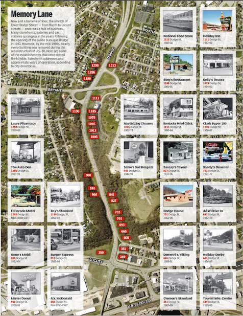
Before 1943 and the opening of the JULIEN DUBUQUE BRIDGE, Dodge Street was primarily residential. Backing out of garages, drivers had only the width of the sidewalk for clearance. Backing into the street, in some cases, was necessary for a clear sight. Gary Potter, life-long Dubuque resident, lived four houses west of the South Locust-Dodge Street intersection as a child. He remembered the area being nearly all Irish with the first German moving to the neighborhood around 1941. As a boy, he played baseball on the grounds of Franklin Elementary School and football near Mercy Hospital. Climbing the bluffs posed no obstacle to visiting the orchards on the top of the hill for an occasional apple. Exploring the bluffs south of his home with a friend, however, led to them becoming lost in a cave system behind the A.Y.MCDONALD MANUFACTURING COMPANY plant. An hours-long rescue attempt proved successful for both boys. Even up to 1963 when his family moved near LINCOLN ELEMENTARY SCHOOL walking across Dodge to visit friends was "easy." (1)
As traffic through town using the bridge increased the average daily traffic count indicated about 24,000 vehicles on the section east of Grandview in the mid-1980s according to the Iowa Department of Transportation. The steep grade left trucks and automobiles forced into nearly impossible driving conditions in winter when the traffic light at Grandview stopped traffic on the hill. (2)
In 1970 proposals to address the street began circulating and were included in the 1990 Dubuque Metropolitan Transportation Plan. Environmental studies were begun in 1980 and the final impact study on the reconstruction of the road completed in 1987. A key to progress on the work was the inclusion of Sister Catherine DUNN on the Iowa Department of Transportation Commission. She served from 1989 to 2001 including a term as chairwoman from 1994 to 2000. As an advocate for the city, she reminded the other commission members that Dubuque had been regularly left out of transportation projects and was not connected to any interstate by a four-lane road despite its many manufacturing industries. (3)
In the spring of 2020, the city celebrated the $20.9 million transformation of the steep curving road bordered by homes, restaurants, service stations, restaurants and even a "doll hospital" into a four-lane, 45 m.p.h. roadway with no stop signs between Bluff Street and Devon Drive. (4)
See: HIGHWAY CONSTRUCTION
Source:
1. Telephone interview with Gary Potter, May 21, 2020
2. Hogstrom, Erik, "Transformed, Dubuque's Dodge Street Reconstruction Launched 25 Years Ago," Telegraph Herald, May 17, 2020, p. 1A
3. Ibid. 6A
4. Ibid.


